To explore Iona National Park and its surroundings, it is highly recommended to call upon specialists with strong field expertise and solid logistics (notably well-maintained and powerful 4x4s). The agency Palanca Safaris, which helped us carry out this report, also offers other itineraries in Angola.
From these shrubs with smooth, purple-tinged trunks and sparse, ghostly leaves in a harsh mineral world, fine translucent layers of bark swirl in the hot wind. An hour’s drive north of Espinheira, in the heart of Iona National Park, these delicate banners signal that life indeed exists here, on such an arid territory… Here, pachypodiums and other xerophytic plants capable of living with almost no water have claimed a schist islet that rises incongruously in the middle of an endless savanna. Around it, the rock wears away, a geological record shedding its pages in the fierce light. Its debris, sharp as razor blades, slices the tires of our 4×4. It is the fourth we sacrifice since the beginning of our excursion into this African natural jewel just emerging from oblivion.
A National Park Born in 1964
Iona National Park spans about 15,000 square kilometers in the extreme southwest of Angola, where it forms the northern tip of the Namib, one of the oldest deserts in the world (55 million years). To the south, the tempestuous Cunene River marks the border with neighboring Namibia. To the north, the Curoca River borders it. To the west, vast sand dunes plunge into the Atlantic Ocean for more than 160 kilometers.
Along this coast, the Benguela Current, which moves up from South Africa, brings up the cold waters rich in plankton from depths, making the area very fish-rich and attracting fur seals and humpback whales.
Protected as early as 1937 by the Portuguese colonial administration, the zone achieved national park status in 1964. But the War of Independence (1961-1974), followed by the civil war (1975-2002), which claimed more than 500,000 lives, devastated the country and ruined much of its wildlife. Farewell to black rhinos, desert elephants, and Angola’s giraffes…
The Threat of the “Zonkies”
After the country’s independence in 1975, the park had become little more than a refugee corridor toward neighboring Namibia for Portuguese settlers. It later served as a retreat for the various factions fighting for power during the civil war; finally, as a rear base for the SWAPO troops (the South West Africa People’s Organization) who fought for Namibia’s independence, then occupied by South Africa… After the conflict, a few herds of oryx, zebras, springboks, or ostriches wandered restlessly in the desert. The large mammals had disappeared. A few cheetahs and rare leopards tried to find prey to sustain themselves.
It was not until 2019 that the park began to emerge from this lethargy. The NGO African Parks, which manages numerous protected areas on the continent, launched the first reintroduction programs. About twenty Angolan giraffes were released into the park in 2023, followed by zebras, springboks, and oryx as their populations grew through ongoing operations. Monitoring of the herds has highlighted the presence of youngsters, a sign that the vast plains can sustain their needs despite the harsh desert conditions.
A 115 years old he is the memory of the Himba people
Mutili Mbentula is a historic figure of the Himba people. Our journalist Jean-François Lagrot, accompanied by Victor Agostinho, a conservation specialist within the park, met him in Erola, where the patriarch lives with his community. The elder says he was born at the start of the 20th century during the genocide of the Hereros and Namas by the German colonial army in what is now Namibia. He recounts having seen black rhinoceroses and elephants (now absent from the region). “Nowadays, rain is scarcer and the milk from goats and cattle is therefore less abundant, he notes. The Himba are surviving more precariously and the young people are gradually drifting away from the traditional lifestyle. I fear that our traditions will disappear with time.”
Zonkies, Hybrids Between Zebras and Donkeys
In a second phase, emblematic species such as the rhinoceros would arrive. But these require a level of surveillance that the African Parks teams do not yet have in place.
Today’s wildlife monitors, recruited from local ethnic groups, notably the Himbas and the Mucubals, ensure the tracking of animal populations and liaise with communities living on the park’s edge to ensure livestock does not compete with wild herbivores.
Another threat, more unexpected, looms over the zebra herds. “The villagers’ donkeys sometimes return to the wild and join the zebras, leading to the birth of zonkies [zebra-donkey hybrids], says Daniel van der Vyver, African Parks’ head of field operations. And zonkie males, often dominant in the herds and sterile, prevent others from reproducing. They thus block reproduction in the herds for years.”
During a flight over the park, we even spotted a black stallion galloping through the reg—mane blowing in the wind! Horses, too, sometimes revert to the wild.
Not a Trace of a Traveler
Wild… that is the adjective that applies to the vast expanses of Iona. Beyond the rough terrain, the lack of infrastructure (no developed campsites, only a lodge under construction near Espinheira) and still-rare fauna, this land of origins with remarkable geology carries a scent of freedom long thought extinct. The rest of southern Africa, as beautiful as it is, has become an amusement park where you meet lines of vans and all-terrain vehicles. Over the ten days of our exploration of Iona, we will not cross the shadow of a traveler. In this remote and austere territory, you cannot rush in: two vehicles loaded with jerrycans of fuel and abundant water are needed to traverse the park. And don’t count on a phone or internet connection to extricate you from a tough situation…
Near the town of Tombua, the northern gateway to the park, the wind guides us through a maze of ochre, red, and yellow sandstone formations, up to 25 meters high. Colinas do Curoca, also called the Valley of the Spirits, is a massif of alluvial rock formed during the split of the African and South American continents, the result of the Curoca River’s power, intensified by wind erosion. Legend says tribes sheltered there when the Portuguese arrived in the 16th century, singing chants that, amplified by the cavities and the labyrinths in the eroded rock, supposedly frightened the invaders. Located northeast of the park, the lands of the Mucubals, a semi-nomadic Bantu people, hide a sacred site.
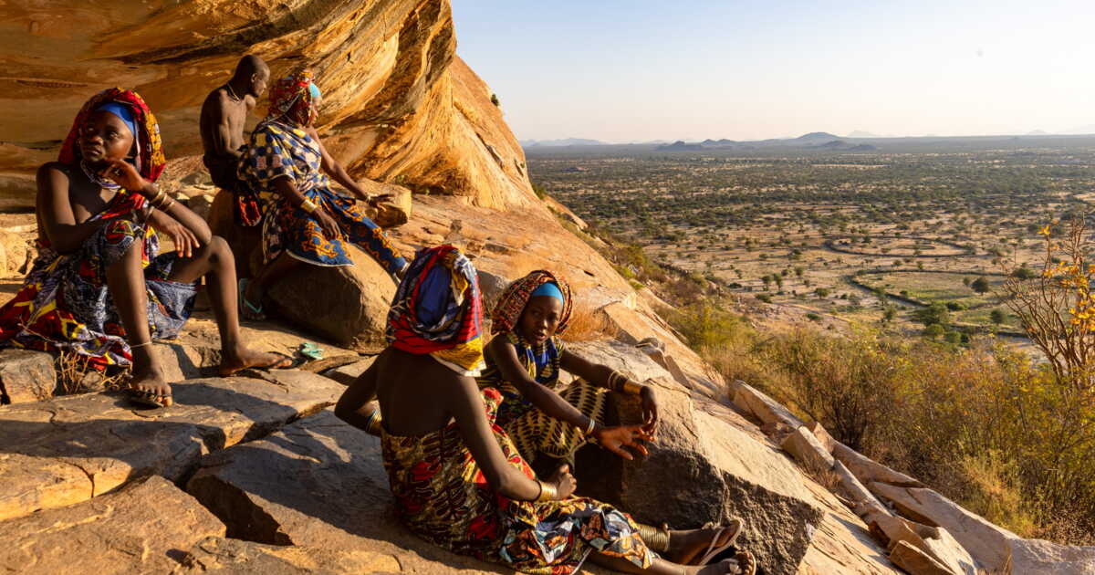
There, at Tchitundu-Hulu, in the crevice of a granite dome that looms over the Mopane Veld — named after the mopane (Cholophospermum mopane), the southern African tree found in this plain — a treasure of rock art was discovered in the 1950s. White and red paintings depicting fish, birds, and geometric motifs adorn these rock faces. The site was likely frequented by hunter-gatherers who predated the San people, who inhabited the region before the Bantu. To reach it, one must first obtain the soba’s approval, the clan chief, then slip between kraals (the livestock enclosures). The corn and bean plots next to the huts are surrounded by thick thorn barriers to protect them from livestock and potential predators.
Precious Rocks
Led by young Mucubal girls wrapped in vividly colored wax, we climb an inselberg, a giant stone with a granite shell formed by granular plates: these plates crumble away, taking with them concentric circles carved in the rock for at least four thousand years. We feel the giant living beneath our feet… Veins, the pegmatites, cross the granite. Usually rich in silicate, they sometimes contain topaz, aquamarine, tourmaline, and various quartz derivatives…
The Mopane Veld stretches to the horizon. Broad calderas surround vast golden savannas that ripple under a bright horizon. Flows of cooled lava emerge from a collapsed caldera.
From Tombua, we rejoin the national park and head south along the coast. For about 160 kilometers to the Cunene River’s mouth, majestic dunes plunge into the Atlantic. Some have violet reflections that betray garnet dust; others, stained black, hide magnetite. To reach Foz do Cunene, at the southern tip, it’s best to choose the day carefully. For the ocean only withdraws enough to pass at the foot of the dunes during full moon and low tide.
Recently, a South African 4×4 was swept away by the waters, unable to reach Tiger Bay in time, a bay said to owe its name to the zebra-oxide stripes on the nearly vertical dunes. In the bay lies Tiger Island, once a peninsula with a fate sealed by the sea. The waters were especially fruitful for fishing, and the Portuguese long occupied it. A small town with its church, its fish-processing plant, and its airstrip once housed a few thousand inhabitants. But in 1964, a terrible storm broke the isthmus that connected it to the continent and cut off the freshwater pipeline that kept it alive. Today there remains a ghost town, buried under sand.
Crocodiles in the Reeds
Further south, the Angolan garrison at Foz do Cunene holds the last stand before Namibia. An African version of the Desert of Tartars (Dino Buzzati, 1940). A few crumbling buildings, bullet holes, sand heaps assaulting fragile walls. Seven border guards are rotated every three months, supplied by a track that winds endlessly through soft sand, amid “gardens” of Welwitschia mirabilis. This desert plant hides its true nature, with its two only leaves scorched by the sun, making it look from afar like a torn tire… In reality, it can live two thousand years and reach several meters in diameter, drawing moisture from the fog droplets carried by the ocean.
A hundred meters from the garrison, the Cunene River, a jade-colored artery between Angola and Namibia, scarcely invites swimming: locals say that dogs belonging to the border guards, who come to drink from its cool waters, are a tempting prize for Nile crocodiles. These crocs proliferate here, lurking among the reeds, according to a tall fisherman with a cane who strongly suggests we go wading elsewhere…
Further upstream, to the east, at the place called Cunene, the bivouac is idyllic. The Milky Way explodes in a sky free of light pollution. Around 8 p.m., the Scorpius constellation seems to rest its tail on the dunes, Antares glows a thousand orange lights… Further upstream yet, the Marindi Falls near Tchinhungua and then Epupa Falls announce themselves by the roar of their powerful columns of water cascading down. They are hard to distinguish amidst the meanders and the islets covered with makalana palms (Hyphaene petersiana) whose trunks rustle beneath the weight of vervet monkeys hiding there.
A Celebration for a Cow
To the east of the park, Iona—the town that gave the park its name—is a small town with administrative buildings oddly painted blue or pink. Some Himba communities live nearby. Further east still, a constellation of camps of various ethnic groups orbits around Oncócua and its market. Along the roadside at dusk, we meet a young Mucawana, wearing a solar-powered radio across his shoulder that crackles out Angolan tunes. The boy returns to the village to attend a feast organized for the slaughter of a cow.
We follow him. The Mucawanas, who live in the surrounding mountains, are sometimes called black Himba because of the color of their headdress, due to a mixture made from cow dung — the real Himba is tinged with red earth. They are herders and semi-nomadic cultivators, enjoying a certain tolerance from authorities on both sides of the border, who allow them to cross freely. They welcome us among them. The assembly claps in cadence, forming a circle in which women enter one after another, then spin around themselves before pointing to a man who joins them…
In the nearby kraal, a cloud of flies hovers above a cow carcass hacked open with a machete. The women laugh. A moment of grace in this vast, still little-known territory, thousands of miles from the world’s clamor.
Field Report: Jean-François Lagrot, Photojournalist
“The bivouac possibilities are fantastic, but you must be cautious”
A seasoned expert of Africa’s landscapes and wildlife, Jean-François Lagrot was impressed by southwestern Angola: “Traveling in Angola today means traversing a country that remained virtually closed to travelers for fifty years”, he says. Since 2023, Angola has opened up to tourism, waiving visas for 98 countries, including France.
“Now is the time to go!, notes our reporter. However, beware: Iona offers fantastic bivouac possibilities, but it demands good logistics, as water points are scarce, tracks are difficult, and infrastructure is non-existent!
➤ Article appeared in GEO magazine no. 573, “Scotland, generous and proud”, November 2026.
➤ Do you love GEO? Then to never miss a beat, discover our subscription options to receive GEO every month at home with ease.