Summary
-
A historic hike
-
With these ponies, it’s wise to keep a safe distance
-
These smuggling routes were also used by the resistance
-
Our steps cross the legendary GR 10, which traverses the Pyrenees
“It’s better here than packed like sardines on the Saint-Jean-de-Luz beach!” Jean-Pierre, a cheerful fellow with a black beret, speaks with a jovial authority. In mid-March, the retiree, “ex-charpentier”, teases his three companions visiting the region. To show them more than the usual tourist spots along the coast, he leads them to the Venta Yasola, “the place of reeds” in Basque, perched near the Spanish border. At 400 meters above sea level near the Subizia pass, this small, plank-clad inn is reachable only on foot, after about an hour’s walk from Olhette, a neighborhood of Urrugne.
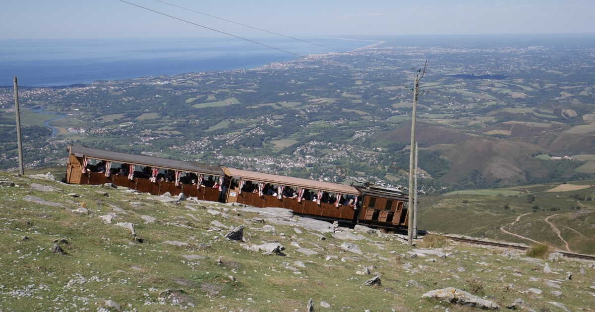
It’s one of many ways to wander the Rhune massif and, if one feels up to it, to approach its nearby summit. With a shark-fin silhouette that stares out at the shifting blues of the Bay of Biscay, the mountain holds significance for the Basques far beyond a mere landmark; it’s a familiar sentinel and protector. Each year it draws a flood of visitors, most of whom take the gentler route aboard a cog railway, while others attempt the ascent on foot via the Ascain path, a highly walked route in summer. Rather than tackling the monument head-on, we chose to explore the surrounding area. The Rhune massif, besides its main route to the summit, hosts around twenty trails of varying lengths, weaving through mid-mountain landscapes typical of the Basque hinterland. It’s enough to measure the icon’s presence before perhaps attempting to go all the way to the top.
A historic hike
After climbing to the Subizia pass, we set off on another approach from Basaburua, Sare, at the foot of the eastern slope. Behind a row of well-to-do white houses, with red timber framing, lies the starting point of a sporty loop. Branded as “From pass to pass,” the signs announce the challenge: 11 km and 690 m of elevation. Four hours of uphill, downhill, then up again: not Everest, but a route that demands some pep. “On September 30, 1859, Empress Eugénie de Montijo, Napoleon III’s wife who summered in Biarritz, passed here to reach the summit. She did so again in 1862 and sparked the fashion for hiking on the site,” explains Guy Lalanne, founder of Jakintza, an association dedicated to Basque memory and culture. Back then, every convoy flirted with adventure. Try to fathom why Eugénie and her entourage, a privileged circle of about fifty, chose the steepest wall to reach the top. “They endured remarkable hours simply due to a lack of equipment,” adds the former road official with encyclopedic knowledge. “If Eugénie rode in a cacolet (on a mule), many were on foot. Those nobles and princesses didn’t have sneakers!”
Well-equipped and following the now well-marked path, the risk of running into such obstacles is minimal. As we ascend, the Pyrenees unfurl behind us, serene, dusted with snow in places. On the stony path lined with ferns and heather, we notice small heaps of horse droppings. No need for a forensic investigation—the jingling bells quickly guide us to the culprits. With manes flying in the wind, a handful of pottoks, those short-legged wild ponies with white and brown coats, graze with the Rhune summit in the background, hardly bothered by our presence or by our accusations.
With these ponies, keep a safe distance
“Like sheep and cattle, they have kept the mountain alive for centuries”, explain Jean-Louis Laduche, 69, and Marie-Laure Roumy, 66, co-presidents of the Pastore Lore association. Created in 2004 to honor shepherds of the region, the group gathers around fifty owners… including them. “Pottoks are sturdy animals, able to endure outdoor life in all seasons. There are about 350 here, roaming freely, but the herd is shrinking,” they note. We back the herders by funding certain veterinary care.” Facing these rustic, endearing creatures, the best approach remains discretion. “Keep your distance. A single kick can come quickly,” warn the duo, who also remind us that “in pastoral zones, dogs must be kept on a leash.” With the surge of hikers, some behaviors begin to irritate those who dedicate themselves year-round to maintaining the mountain’s balance.
A figure appears around a rock—the first hiker we meet after about an hour and a half of climbing. Kevin, in his thirties, hoodie, jeans, sneakers, seems a bit lost. “Google Maps is useless!” he mutters before summarizing his misadventure: “I came from the summit. I followed the markings to climb, but on the way down I must have missed something.” With a topo guide in hand, we point him toward the best trail to reach his target. But Kevin is stubborn. He chooses to follow the cog railway’s line, which carries nearly 300,000 travelers each season, “to avoid making another mistake” even though it’s forbidden.
“We’ve lost the mountain-going codes, laments Émilie Praï, a development advisor at the Departmental Tourism Agency. The Rhune, with its train that climbs to the summit in thirty-five minutes and its closeness to the coast, creates a false sense of ease. Rescues happen frequently for falls, sprains, or when people get lost due to inadequate equipment. We’ve even seen visitors arrive in flip-flops!” Planning ahead by downloading the GPS track of your hike and checking the weather on the same day (“because the sky changes quickly on this massif exposed to Atlantic influences: storms, showers, and gusts can sweep in from the sea”) are considered essential basics, stresses the technician.
For our part, the idea of climbing all the way up remains off the agenda for now. We continue our explorative circuit. The Col des Trois-Fontaines, 545 m above the ocean, lies ahead—a junction of several trails that provides shade and a breath of cool air. A couple dozes beneath the leafy boughs of an ancient pedunculate oak. Nearby, peat bogs appear—marshy or sponge-like zones harboring surprising flora and fauna that attracted botanists as far back as the eighteenth century. “In the summer, you can easily spot sundews, remarkable carnivorous plants,” notes Patrick Bonifas, 61, head of the Basque Country Territorial Unit at the ONF (National Office of Forests), responsible for protecting the Natura 2000 site. “The Rhune is environmentally rich. There is a diversity of habitats, despite the acidic rocky soil that releases few minerals for vegetation. It’s offset by abundant rainfall. There are many streams and watercourses, sometimes invisible to the eye but very audible.” The massif hosts plant and animal species of exceptional heritage value, such as the prune-borer beetle, the Alpine rosalie (one of Europe’s most beautiful and rare beetles), and the great SOLDANELLE, a cliff-dwelling plant with violet flowers.
These smuggling routes also served the resistance
We return on foot to the starting point, then drive to Urrugne to begin another, less strenuous walk—the Mulets trail—which unveils another facet of Rhune’s history: the gauazko lana, “night work” as the Basques call it. “Ah, smuggling… It’s a whole story here!” smiles Guy Lalanne. The mountain forms a natural border between Labourd on the French side and Navarre on the Spanish side. “From 1840 onward, after the first Carlist War and the Basques’ defeat, customs officers settled here. The trade began then, but mostly out of need and ingenuity. Farmers, herders, families… everyone pitched in to survive, or simply to pay less. It wasn’t a black market for wealth.”
Until the 1950s–60s, tobacco, alcohol, medicines, and also car parts and bodies “cut with a blowtorch, carried by man or mule, then welded back together” crossed the border at night, along these steep slopes toward Spain. In the opposite direction moved coffee, soap, and clothes. On the ground, slabs of sandstone worn by wagon wheels still bear witness to this discreet commerce. “Let’s not forget that these paths also helped many to escape: Jews, resistance fighters, among others.“
Our steps cross the mythical GR 10, which traverses all the Pyrenees
We resume along a wide track. To the left, the Rhune’s summit and its antenna rise as a distant beacon. To the right, conifers have recolonized the slopes after the war. Above them, a string of sunlit car windshields—cars parked along the crest—gleam in the light. The Ibardin Pass sparkles as a bright point on the horizon. This border stretch is also home to the so-called “deal runners” who descend to Basque shops in search of cheaper fuel, cigarettes, alcohol, and perfumes in duty-free outlets.
Arriving at the Ibardin Pass, just after the oversized “Pastis Prado” sign, we begin a stretch of the GR 10, the legendary route that spans the length of the Pyrenees. The path winds gently through the forest and leads to the charming Inzola stream. Before reaching it, we pause at the Col des Abeilles, a place whose name is no accident. A few pollinators buzz around, welcoming us. Here lie the ruins of a shepherd’s hut and the Carrier’s Pier, a fifty-meter wall that testifies to sandstone extraction still active elsewhere in the massif. A dolmen also emerges along the way. “There are several dolmens on the Rhune, as well as a large number of cromlechs,” notes Guy Lalanne. “Neolithic shepherd-gatherers already lived on these heights thousands of years ago. They weren’t after a view; they were seeking a livelihood.”
For today’s visitors in the 21st century, it is the panorama that commands attention. To the west, the peaks dip into rolling hills, gradually flattening toward the Atlantic. To the east, the mountains rise higher, shaping themselves into real ranges. While the Rhune’s silhouette stands out, it becomes clear that there’s little point in racing to the summit: by circling around it, we grasp what matters most. “There’s no need to stamp your ticket on the summit plateau, as is fashionable,” confirms Nicolas Bernos, 39, a mountain guide with Ramondia. “The off-path trails offer what is most valuable: serenity. And the Ascain route, the most travelled, is eroding under the pressure of crowds; some sections already require redesign or detours.” The Rhune isn’t conquered by a straight ascent. It’s tamed gradually, by taking all these paths that, while never actually reaching the top, lead you there more surely.
And elsewhere
Two other summits to contour for better enjoyment
- Mont Aiguille from every angle A colossal calcareous spike perched on the eastern flank of the Vercors massif, Mont Aiguille is one of Dauphiné’s most emblematic peaks. Its first ascent in 1492 marked a milestone in mountaineering, and it has shed its old label—“the Inaccessible Mountain”—as crowds now flock to its base. To enjoy it, take the loop that circumnavigates the rock rather than scaling straight up. Route: a full-day circuit is possible but strenuous; begin from the north and plan a mid-loop stop at Chichilianne in the south for a gentler pace.
- A Puy full of resources Easily accessible by cable car, the Sancy Puy, the highest volcano in Auvergne, sometimes earns a reputation for attracting ever-growing crowds to its summit (1,885 m). Fortunately, there is plenty to explore nearby, especially during the Horizons “Arts-Nature” festival in Sancy, which each summer decorates the Dore mountains with ephemeral artworks. The program: at the summit, in the heart of a forest, or inside a hollow of a valley… For its twentieth edition, the festival plans ten installations visible from June 20 to September 27. Add to this some works from earlier editions that have become permanent, and you’ll have a rich menu for many wanderings. Find more details at horizons-sancy.com.
➤ An article to be found in GEO’s Special Issue No. 133, June-July 2026, “France, our favorite strolls for the summer,” on stands
➤ Do you enjoy GEO? Then discover our subscription options to receive GEO every month at home with ease.

Amara Nambinga