At first glance, they might look like simple lucky charms left behind by passing travelers. Yet the thousands of coins pressed into the rocks of the Giant’s Causeway, in Northern Ireland, forced conservationists to launch a particularly delicate cleaning operation. More than 20 kg of coins have already been removed from this UNESCO World Heritage site. And despite several months of intervention, thousands of coins remain trapped within the rocks.
A meticulous operation at the heart of an exceptional volcanic site
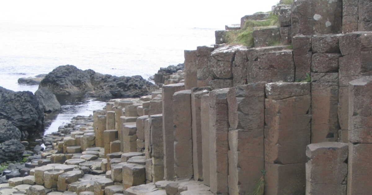
Located in County Antrim, in Northern Ireland, the Giant’s Causeway is one of the United Kingdom’s most famous geological landscapes. The site contains more than 40,000 basalt columns, formed about 60 million years ago during a volcanic activity. Molten rock flowed into the fissures of the Earth’s crust before cooling, contracting and fracturing, giving birth to these columns with their characteristic geometric shapes. The site is registered as a UNESCO World Heritage site.
It is in the interstices of these formations that visitors gradually began to wedge coins. The gesture seems to carry symbolic significance, with some tourists considering the money as a good luck charm or a sign of love. But the coins remain exposed to sea spray and humidity, and their prolonged presence in the fissures can become problematic for the rocks…
The National Trust therefore undertook their removal in May 2025, after an alert from the Geological Survey of Northern Ireland. Early observations had highlighted effects that were both physical and chemical on the basalt. The intervention required the expertise of a stone mason, Nathan Morrow. The teams could not simply pull the coins out for fear of damaging the columns. Pliers were used for those near the surface, while a jointing tool allowed access to coins wedged deeper in the cracks.
The difficulty varied greatly from one place to another. Some coins came out quickly, while the most deeply lodged ones could require more than 20 minutes of work each. In total, the operation involved around 200 hours of work. “Approximately 200 hours of work were devoted to the project”, said Cliff Henry, the National Trust’s nature engagement lead, to Need To Know.
Salt accelerates corrosion of coins stuck in cracks
But the problem is not limited to the number of coins scattered on the site. Their composition and the conditions to which they are exposed can also worsen their impact on the rock. British copper coins minted since 1992 notably have a steel core coated with copper. The 5, 10, and 20 pence coins are, meanwhile, made of steel coated with nickel. Yet these metals do not react to the environment in the same way. With humidity and especially the salt brought by sea spray, corrosion accelerates. The different metal layers can separate and expand inside the cracks, exerting pressure on the basalt.
This degradation also makes the coins difficult to identify after a few years. “The coins corrode so quickly in the salty and humid conditions of the Causeway that it becomes impossible to determine what currency they were, not to mention their date, after only a few years”, explained Cliff Henry.
The majority of recovered coins unsurprisingly came from the United Kingdom and the euro area, visitors tending to use the currency they have in their pockets. Only a portion could still serve as money, the others being too deformed or corroded.
Despite these hours of effort, the cleaning did not manage to remove everything. Several thousand coins would thus remain wedged in the cracks. Some are now too deeply buried to reach. Others are so rusted that moving them could further damage the rocks.
Cliff Henry, for his part, compares their accumulation to a carnival ride in which new coins gradually push the older ones inward. “As in a Penny Falls game in an arcade, the coins have been pushed further into the joints by the new coins hammered in at the front”, he explained.
The phenomenon could therefore continue to pose problems even after the end of the main operation, completed in June 2026. New coins have already been found after the cleaning, including 42 removed by Cliff Henry last month. The National Trust now plans to monitor the formations regularly and remove new deposits.
Informational panels have also been installed to ask visitors not to push coins into the rocks. The National Trust also plans to turn a portion of the recovered coins into objects for display to concretely demonstrate the consequences of this practice.
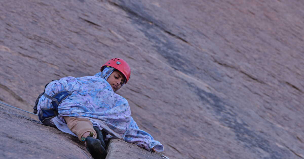
Mounina Bero, 17 years old, eyes the void beneath her feet, then remains motionless on a rocky ledge of Ben Amira, twenty meters above the ground, stubbornly refusing for long minutes to abseil down. Her elder sister, Kallat, encourages her from below, having taken up climbing two years ago, not without first overcoming the reluctance of the people in her village – after all, no one here had ever seen a woman do such a thing! Since then, the young girl dreams of becoming a tour guide specializing in rock climbing.
Paths Toward the Future
It is a group of French climbers, led by Jean-Louis Lauféron, an osteopath and mountaineer, who have been opening routes on the stone sentinels of Mauritania for six years. “When we first came here, these monoliths were not only pristine but utterly unknown: on the Internet, it was as if they did not exist!”, recalls this energetic man, cofounder in 2005 of the association Medicine and Mountains of the World, whose mission is to blend a passion for summits with the development of African villages – for instance by funding French lessons for Kallat to help her pursue her dream. Even camels die of thirst, See the Crack, The Law of the Desert or The Origin of the World – a tribute to this gigantic fault, on the west face of Aïcha, which inevitably calls to mind Gustave Courbet’s notorious painting: 27 climbing routes with evocative names have been established in the area. And the adventure continues…
➤ Article published in GEO HS magazine No. 134, “Great Escapes at Slow Speeds,” August-September 2026.
➤ Do you love GEO? Then to never miss a thing, discover our subscription plans to receive GEO at your home every month with ease.
On the roads of Cantal, everyone knows that slender figure with a determined stride, a walking stick in hand, a black beret crowned with a small cow on the head. Each day, Brother François, with a youthful look beneath his white hair, goes from farm to farm to help milk the cows, cut the hay, or repair the fences. François Cassingena-Trévedy, by his civil name, is a regional figure, known far beyond his village of Sainte-Anastasie, reaching Murat and even Aurillac. This affable 66-year-old man defines himself as a peasant monk. An Alsatian, a Normalien, a theology professor, a translator of Virgil, he is also a poet and writer, author of 25 books. One of them (Cantique de l’infinistère, ed. Desclée de Brouwer, 2016) speaks of his love for Auvergne by recounting a walk through the volcanoes that changed his life.
“C’est un pays rude, austère, raboteux, mais aussi sensuel, dit-il depuis les plateaux herbeux qui dominent son village. Un bout du monde infini, où les montagnes sont comme de grandes houles de lave solidifiée. C’est en marchant que j’ai décidé de quitter mon monastère pour me dédier à cette terre et à ses habitants.”
To feel, like him, this telluric summons, nothing beats setting one foot in front of the other on the volcanic bedrock of Auvergne — basalt, phonolite, Volvic stone, pozzolana… — while contemplating the conical mountains and the valleys that lie ahead on the horizon. And why not undertake the Grande Traversée des Volcans d’Auvergne (GTVA)?
The Great Volcanic Crossing
This new itinerary, created in 2024 and spanning the départements of Puy-de-Dôme and Cantal, invites you to discover the natural heritage of the region, from the iconic Puy de Dôme (1,465 m) to the Plomb du Cantal (1,855 m), passing through the Sancy massif, the Cézallier plateau and the valleys of Puy Mary. Open to all, it stretches 210 kilometers and can be completed in one go in eleven days for the bravest, but one can of course choose only a portion. Arriving in Cantal, some travelers may cross Brother François along the last third of the route. “We imagined this itinerary as a condensate of the region’s beauties – peaks, plateaus, rivers, lakes, villages – using the already existing GR [long-distance hiking trails], explains Michel Faure, local head of the French Hiking Federation, who designed the 98 kilometers of the route in the Puy-de-Dôme.
The zero-kilometer point of the GTVA lies on the heights of Chamalières, in the greater suburb of Clermont-Ferrand. On the information panel, there is a map, some basics of geology and safety instructions. The Massif central may often be thought of as a “mountain of cows,” but it is still a real mountain, with its dangers and its changing climate. And to tackle the 8,500 meters of positive elevation, good shoes and off-road clothing are essential.
Volcanic Scoria Screeches Underfoot
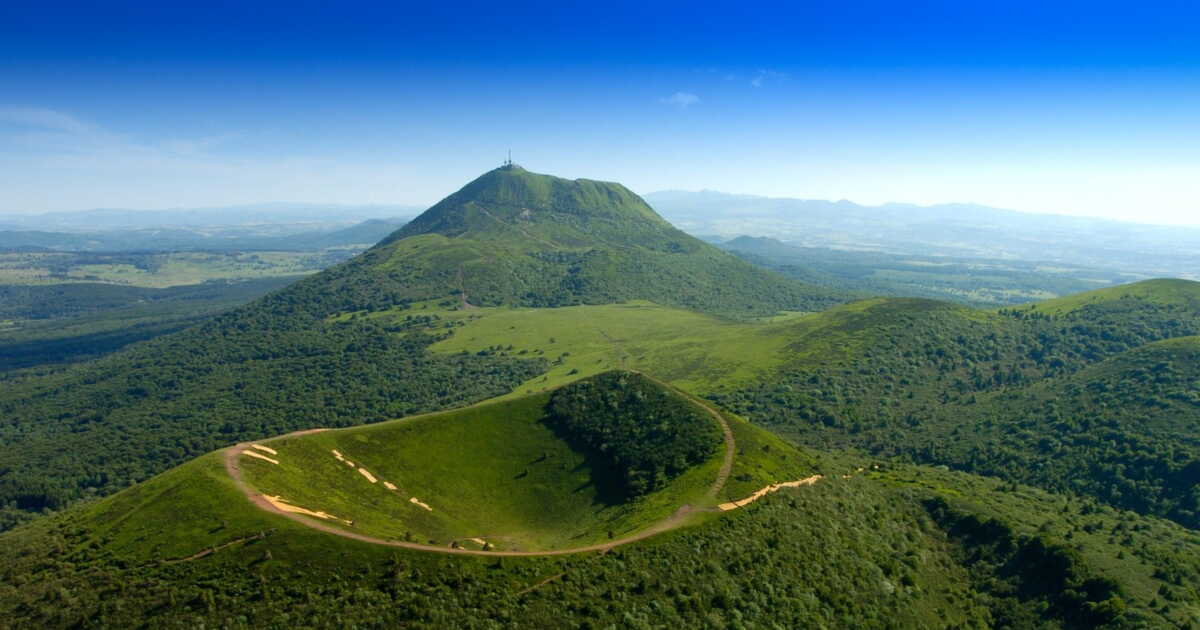
From the first stage (fifteen kilometers between Chamalières and Laschamps), the trail stubbornly climbs through woods and pastures. We trek on a ground studded with pouzzolanic rocks (volcanic scoria) that screech underfoot. Then comes the steeper climb toward the Puy de Dôme. The many hikers who ascend it each year often forget that this merely sleeping volcano is of the peléan type, meaning dangerously explosive, with pyroclastic flows, while the other volcanoes of the Puys chain — also dormant — are strombolian, with regular eruptions of scoria and lava. At the summit, the cool wind, which can surprise in any season, pleases paragliders. The Puy de Dôme, a young volcano with its last eruption dating back 11,000 years, may owe its name to its shape (dumio, Gaulish for hill). Up there, one discovers the imposing remains of a IInd-century Gallo-Roman temple dedicated to Mercury, god of commerce, thieves, and travel, but also a meteorological observatory and a small station for those who prefer a cog railway. This belvedere offers a splendid view of what awaits hikers: 80 craters aligned along about 35 kilometers, inherited from a sequence of telluric cataclysms dating from 200,000 to 11,000 years ago.
In this epic universe of sharp cones, rounded domes, and high-altitude lakes, the crossing continues. In the darkness of beech and conifer forests, on the exposed slope of the summits where herds of cows graze, skirting the hills and following the ridge lines, the GTVA offers a great diversity of landscapes. The trail, located mostly above 1,000 meters, sometimes intrudes on pastures, with the farmers’ permission. At the top of the Puy de Dôme, one is amazed: 80 craters aligned along 35 kilometers, heirs to a sequence of telluric cataclysms dating from 200,000 to 11,000 years ago.
Beside the Valley, Heaven Lies in Saint-Nectaire
It is in this epic universe of sharp cones, rounded domes, and high-altitude lakes that the crossing continues. In the darkness of beech and resinous forests, on the exposed slope of the summits where cattle roam, circumventing the hills and following the ridgelines, the GTVA offers a rich variety of landscapes. The trail, mostly above 1,000 meters, sometimes edges onto pastures with farmers’ consent.
About halfway through the second stage (between Laschamps and Lake Servières), one admires the village of Orcival and its impressive walls of andesite (a volcanic stone), before slipping to the west of the trail to reach the paradise of Saint-Nectaire. The Planchettes farm, perched on the hillside and active for two centuries, hides a treasure. In 1946, the owners discovered a well 18 meters deep. For two and a half years they dug with pickaxe a 100-meter gallery to tap the water. The result: the place, with its constant humidity (90%) and 10 °C, became an ideal cellar where a thousand farm-produced AOP cheeses mature — they produce 70 each day. “There are only a few dozen Saint-Nectaire producers left who, like us, age the cheese on the farm”, notes Marlène Gratadeix, 44, from a farming family for six generations.
A Breath of Fresh Air in the Heart of the “Diagonale du vide”
At the end of the second stage, just a stone’s throw from Lake Servières, Café du Lac offers lodging and meals (including a famous blueberry tart) at the crossroads of GR 30, GR 441, GTVA and the Grande Traversée du Massif Central, a MTB route. “I’d been coming to this refuge for forty years, it was very rustic, and when I had the chance to buy it in 2017, I didn’t hesitate!” recounts its owner, Michel Fabre, 63, a hiker since always. “A lot of people tell me it’s the finest section of the GTVA, with wide open spaces, a view of the Puys chain and the Sancy massif.” On the exposed plateau of Lake Servières, grassy mounds mark old transhumance trails, or burons-trous, shelters built by medieval peasants for aging cheese. “These open mountains, easy to approach but of great beauty, with volcanoes as a guiding thread, are attracting more and more hikers since Covid-19,” notes Michel.
“I especially notice a return to bivouacking among young people.”
Six kilometers to the south, the trail runs along Lake Guéry, the highest lake in Auvergne (1,244 m), sparkling at the heart of the Dore mountains. In the distance, the Puy de Sancy, the highest point in the Massif Central (1,885 m), rises. Nathalie Duquesne, 63, has fallen in love with this horizon, with the calm and the starkness of the places. This great traveler, “on motorbike, by boat, on foot…,” she has settled here and took over the Auberge du Lac de Guéry and the adjacent farm ten years ago. She dreams of opening an artist residency in her barn. Summer concerts have already taken place there, drawing dozens of curious visitors, a breath of fresh air in this region situated on the heart of the “diagonal of emptiness.”
A hiker steps over a stream in the Fontaine Salée cirque, one of the Sancy massif valleys located in a nature reserve.
The third stage ends at Mont-Dore. The place hosted France’s third ski resort in 1937. It even earned the nickname “Petit Cham” (in reference to Chamonix), because people practice ice-climbing, skiing, snowshoes… Patou Vergnol, 56, knows this high Dordogne valley by heart where she works as a ski instructor in winter and a hiking guide for horses in summer. Always with the Sancy on the horizon. “I love this accessible mountain, not stark but grassy and gentle to the eye,” she says. “On these wide expanses, you see far. On horseback, the sense of being in a new world is total.” For her, all four seasons are beautiful here: “Spring flowers, a very green summer, autumn colors, then the white breath of winter.” She also explains what “pleige” is, that uncertain mix of rain and snow, and a “ébouriffée,” a sudden gust that can tilt you into winter. We still have about 40 more kilometers to reach Égliseneuve-d’Entraigues, the gateway to Cézallier, at the border between Puy-de-Dôme and Cantal. One feels far away, very far, as one discovers this “little French Mongolia.” If one strays a bit from the itinerary, one encounters barren hills, lost burons, out-of-season hamlets, life at a standstill.
Field report by Olivier Joly, photographer and journalist
Facing the ruggedness of volcanic landscapes and the vastness of the sky, our reporter has “sometimes felt as though I were in lands farther away I have roamed a lot, Patagonia or Iceland, where powerful nature sits alongside a living ancestral tradition of livestock farming. Nights spent at the buron, wrapped in the silence of desolate plateaus, have further reinforced this sense of retreat from the world, in a region that is nevertheless so close and accessible.”
A crossroads of commerce and a land of refuge
Here is a land steeped in transhumance history, the most numerous cattle in France. “The Cézallier is a peaceful yet powerful place, a link between the Sancy and the Cantal, a place to recharge,” says Philippe Glaize, 73, whose family has lived on the plateau since the 17th century. “It is a cattle-raising land for 4,500 years, a migration land since the Middle Ages, when peasants went to sell their hemp and merchants from the North and the Vosges came to trade. It is finally a land of refuge, having welcomed Spanish Republicans, Jewish children, and 5,000 starving youngsters from Marseille during World War II.”
After Cézallier, the Grande Traversée des Volcans d’Auvergne continues to thread southward, with Cantal as the goal. Crossing the Limon plateau brings you to Puy de Niermont (1,620 m), which offers a formidable vantage on this stratovolcano, the largest visible one in Europe, which gave its name to the department. One can also climb Puy Mary (1,783 m), classified as a Grand Site of France, whose panorama justifies the climb. From there, the valleys of Claux, Falgoux, and Mandailles fan out like spokes, each stretching its own singular beauty. “The Mandailles Valley is my favorite for its preserved, green landscape and the jagged horizon shaped by the great summits along the central volcanic ridge,” comments Pascal Saint-Jean, 60, mountain guide.
Knowing how to distinguish Salers, Aubracs, and Ferrandaises
The final stage allows you to travel it before reaching the Plomb du Cantal, the terminus of the GTVA, in three and a half hours of walking from the Lioran ski station (or ten minutes by cable car). From this old basalt dome, the 360-degree view embraces the traversed landscapes, the Sancy, the Cézallier, the Cantal and opens to the Aubrac and the Margeride, at the far edge of Auvergne.
As Pascal notes, those who have wandered these landscapes for decades are unanimous: never has hiking in the Puy-de-Dôme and Cantal (with more than 7,000 kilometers of marked trails) been so popular. Each stage is a source of wonder, with its precious plant species (gentian, narcissus, meadow anemone, sphagnum moss…), its large raptors (kites, falcons…), its chamois and mouflons. We also learn day by day to recognize the cattle: Salers in a mahogany color, Aubracs with eyes rimmed in black, and Ferrandaises, rarer, with lyre-shaped horns and a red-and-white coat… Trekking these sleeping but vibrantly alive volcanoes of Auvergne gives a renewed hope: nature and people can live in harmony.
They helped us with this report
Chamina Voyages, a Massif Central-based agency since 1981, specializes in walking, cycling, and snowshoe itineraries in Auvergne as well as across France and Europe. With flexible or guided group options, it prioritizes nature circuits and authenticity, and favors charming accommodations.
To prepare your stay. Various tourism organizations offer a wealth of ideas for visits, accommodations, hikes, experiences… https://www.auvergnerhonealpes-tourisme.com, Cantal Destination: https://www.cantal-destination.com, Hautes Terres Tourisme: https://www.hautesterrestourisme.fr, Puy-de-Dôme Tourisme: https://www.puydedome-tourisme.com, Val de Sioule Tourisme: https://www.valdesioule.com
➤ Article published in GEO magazine no. 569, “Recharging in Auvergne,” July 2026.
➤ Do you love GEO? Then to miss nothing, discover our subscription plans to receive GEO every month at home with ease.